TEXT AND MAPS BY CHINTAN SHETH
UPDATE: 23rd November
Finally clear views of Katoie Gyang/Kra Daadi’s mountain slope and the Wapra Bung glacier show us the areal extent of the deposits. Satellite images taken on 3rd, 17th and 18th November show a fairly dynamic snow cover, freeze-thaw process ongoing. The images also show that the most unstable part of the Katoie Gyang/Kra Daadi’s mountain slope is still sliding giving off dust plumes.


Above is a comparison of images showing some surge event between November 2020 and October 2021. Also shown is the dynamic environment of freeze, thaw and snow accumulation cycles in the area. Once the fresh snow melts the glaciers reveal their black colour. These vast black lobes is not just glacial debris or moraines but is the glacier itself confirmed from photographs taken at multiple glaciers in this area by mountaineer Tapi Mra, who has worked here for 10 years.
The best possible explanation for why these glaciers are black is because the bed rock here is shale or slate from the Tethyan Himalaya zone. This is also the cause for the Kameng river to be dark grey in colour. Why the entire glacier is a mix of black silt and ice is yet to ascertained.


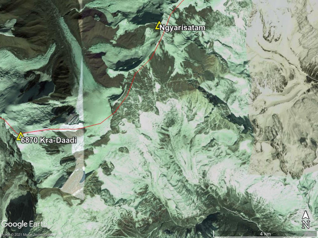
Based on the above satellite images the expanse of the debris flow was 1.5km at the widest in the glaciated valley. Some moraines with vegetation have been covered in debris deposits when we compare the Nov 18th image with the Oct. 1st image. The debris flow then narrowed into a gorge 600m wide before opening up into the valley. The maximum height upto which debris was deposited is as much as about 124m in this narrow portion of the gorge shown by the white arrow head in the November 18th 2021 image.
Local Puroik tribals that witnessed the first event saw a block of ice and rock break off Katoie Gyang/Kra Daadi on the Kameng river side but not on the Wapra Bung river side. They did not observe any debris flow or flood on the Kameng river side on the west of Katoie Gyang/Kra Daadi but saw the debris flow event move slowly through the valley accumulating mud, trees, boulders along the Wapra Bung river valley. They managed to cross the river by felling a tree because their bridge was taken out. When they returned the next time this makeshift log bridge too was taken away. This was likely because of the second debris flood event that took place before 4th November. They believe the mountain spirits were quite upset and have triggered this event. No other animals were found dead other than fish.
UPDATE: 10th November 2021 RE-POSTED FROM MY ARTICLE IN THE ARUNACHAL TIMES
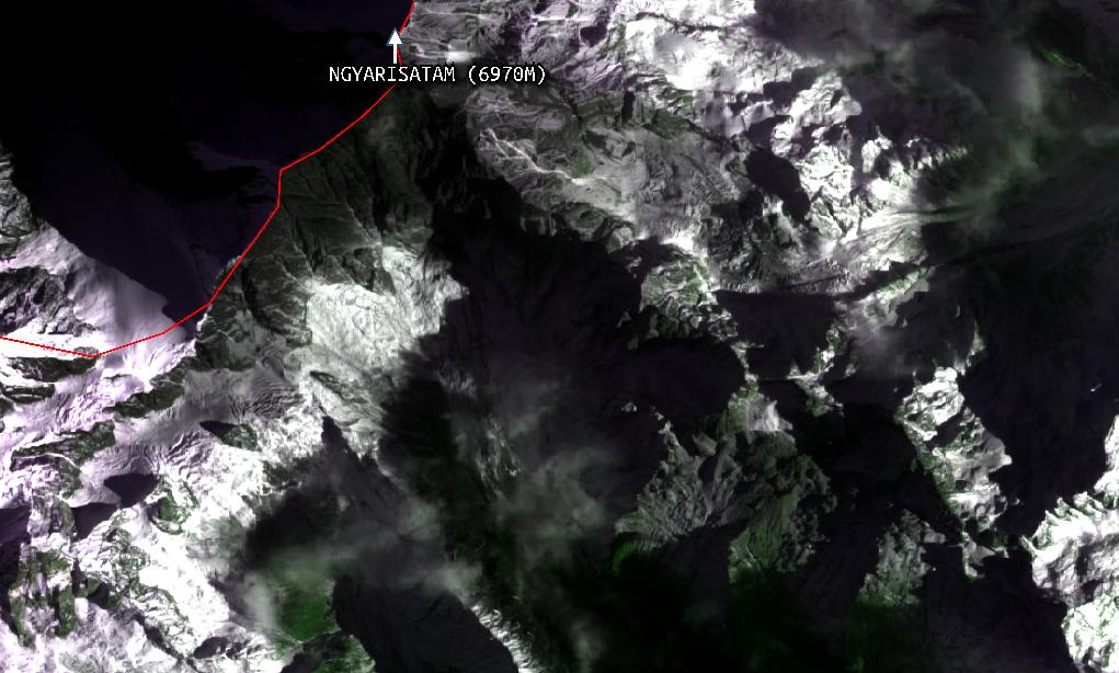
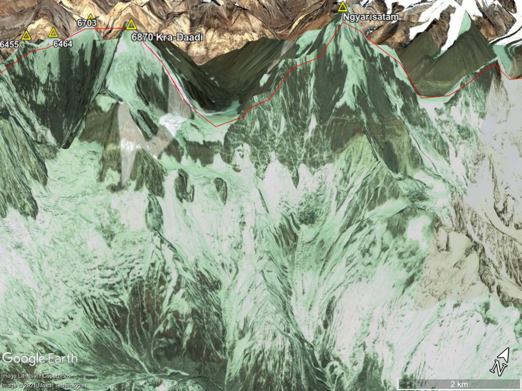
The Kameng river has three large tributaries that originate in heavily glaciated valleys – the Wai Bung, the Pachuk and the Wapra Bung (earlier referred to as the Warriyang Bung, and corrected after checking with the gaon burah of Sario village). All these tributaries are within East Kameng district. These valleys are composed of permanent ice (glaciers), rock, snow and steep mountain slopes that rise up to an altitude of 6,000 m+ ridge separating Arunachal Pradesh and Tibet. The ridge rises along with the grand mountain peaks of East Kameng district such as the Kangto, Katoie Gyang/Kra Daadi and Khyarisatam/Kawang Gyang (names and locations of these peaks have been verified from multiple Puroik locals that frequent the area and local mountaineers).
Given that the earth has been warming since 11,700 years ago and is now warming at an accelerated rate due to historical and ongoing emissions, these glaciers are receding and reducing in size. Such recession creates a complex, dynamic and ever-changing environment. Coupled with the ongoing uplift of the Himalayas, there are additional geomorphic stresses that act on these glaciated environments. These geomorphic stresses are eased by earthquakes that occur unexpectedly.
On 13 October, 2021, the earth sciences ministry’s National Centre for Seismology detected a shallow earthquake of 3.4 magnitude near a ridge separating the Kameng river and the Wapra Bung river. Subsequently, on the 30th, another earthquake of magnitude 3.4 occurred 46 kms southwest of this area. Satellite images of this area before and after 13 October did not reveal any detectable change in the geomorphology here. No landslides were observed. However, by the 29th, the river was already heavy with sediments.
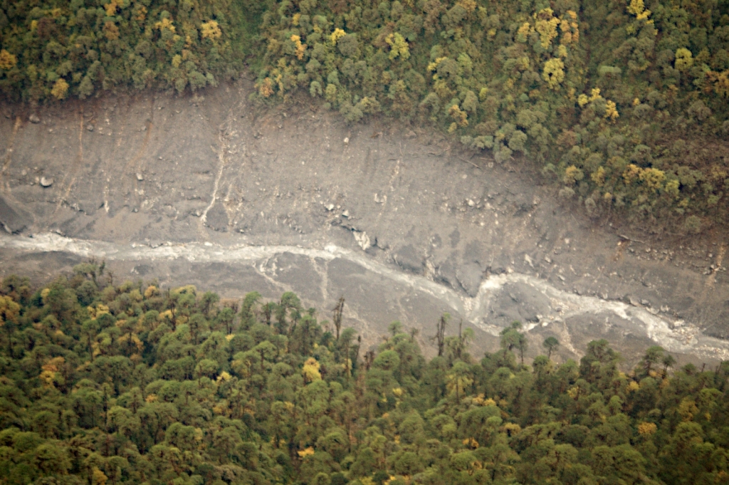
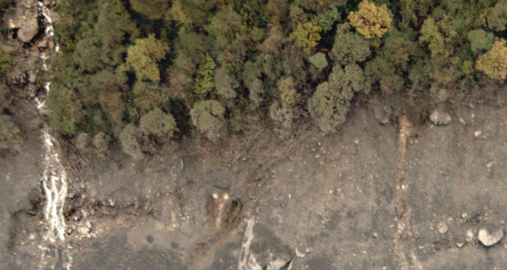
However, on 28 October, a landslide scar was observed in the Wapra Bung river valley, and on the 29th people started observing dead fish, an exceptionally muddy Kameng river and logs deposited by the river’s banks. Satellite images show that the Wapra Bung had significantly widened due to a debris flow. Subsequently satellite images also reveal a large landslide had occurred on the mountain slope above one glacier of the Wapra Bung. The landslide destabilized a part of a glacier, perhaps blocked the flow of glacier channels, and then failed, resulting in the debris flow and siltation of the Kameng river.
While it is unusual for the effects of an earthquake to take effect after so long, there may have been tremors that were undetected due to their low magnitude. Additionally, this region may be composed of layers of rock that are susceptible to failure if destabilized.
The mountain slope above Wapra Bung glacier is exceptionally steep, rising from 3,500 m to 6,900 m in just 8 kms, it culminates into the grand peak known by Nyishi and Puroik people as Kra Daadi/Katoie Gyang(6970m). Satellite images show complete loss of snow and ice on this slope, perhaps due to a combination of factors such as the earthquakes, melting of ice and snow, rainfall and steep slopes. The exact causes are currently being investigated by a team of scientists.
The aerial survey conducted on 5 November revealed significant erosion of the Wapra Bung valley up to 30 kms downstream from the glacier. Preliminary observations suggest that this was a debris flow event (silt and sediment slurry) and not a debris flood event (water with ‘normal’ sediment concentration), based on the damage to vegetation, mud deposits, and the absence of any glacial lake in the past. A ground survey will allow us to confirm the same.


Between 31 October and 4 November a second debris flow event occurred along the valley, expanding the width of the erosion scar five-fold. Thereafter, satellite images show no accumulation of snow on this mountain slope for unknown reasons. An unstable slope seems to be the explanation.

The aquatic ecosystem is under stress as there is exceptional sediment that is reducing dissolved oxygen levels. An analysis by Dr Punyasloke Bhadury of IISER Kolkata has revealed very little photosynthetic activity in the river due to the turbidity. Thus, there is very little food for the fish, and those that survived the debris flow event have escaped into other tributaries that were clear. The protection of fish in these neighbouring tributaries is very important through this ecological disaster, to allow them to bounce back and take care of the Kameng river. This is likely to happen only next year or later, and the citizens of East Kameng must play their part.
Such debris flow events occur through most regions on Earth and are unpredictable. As far as risk to downstream settlements – the weather has cooled but the mountain slope is still giving off plumes of dust, indicating that it is trying to stabilize. No lake formation has happened in this valley as per radar satellite data on 7 November. We scientists and researchers are monitoring this event closely from multiple angles (ecological, meteorological and geomorphological) along with East Kameng district’s deputy commissioner to inform any public advisory and understand if such events can be predicted in the future.
UPDATE: 2nd November 2021
Satellite images taken by Planet Labs Inc. show completely snow and ice free slopes of Nyegyi Kangtsang Katoie Gyang/Kra Daadi (6970m, referred to as Nyegyi Kangtsang on the Tibet side as per this 1955 topo sheet). Nyegyi Kangtsang Katoie Gyang/Kra Daadi is one of the major peaks along with Khyarisatam (Chomo as per the 1955 topo sheet above, Chiumo is probably incorrect as per Google Maps, local Puroik tribals living near the mountain refer to it as Kawang Gyang, Nyishi tribals refer to it as Khyarisatam) along the ridgeline separating Arunachal and Tibet. While it seems like the glacier is much lower down the slope of Katoie Gyang/Kra Daadi Nyegyi Kangtsang, the higher elevations perhaps are composed of just rock, ice and snow.
A comparison of images from 2016 and unusually ice and snow free October-November 2021. Generally the slopes look partly snow free from November – January each year but this year seems more snow and ice free than usual. Coupled with the evidence of an avalanche below the glacier and a debris flow on 28th and 29th October, the probable cause of the muddy Kameng is the collapse the southern slope sometime between 28th and 31s Oct. If this is true and there is debris that has collapsed from this mountain slope then there may still be ample debris in the valley causing Kameng to be muddy. Radar satellite images could have revealed if a lake had formed but the images are not clear enough to make a good inference. Its hard to say how much landslide and debris flow risk remains to downstream communities.


UPDATE: 1st November 2021
Avalanche started on 28th October 2021 as observed by Landsat 7 satellite.
In an image shown below and right, taken on 28th October Landsat 7 shows the avalanche below the main glacier (glacier id G092671E27916N as per GLIMS dataset) feeding the Warriyang Wapra Bung river. This is clearly not a cloud shadow because the sun angle and direction is from the south-east, there are no clouds above the dark triangle shaped area in the centre of the image. Most likely its signs of the avalanche. Green colours in both images indicates vegetation. The two images below are of the same bounding box as show by the graticule markings.

Images taken on 14th October and 1st October of the glacier are mostly cloud-free and do not show any excessive surge or avalanche activity. The avalanche must have occurred before and/or during the period from 28th to 29th October based on the 28th Landsat 7 image above. The river is still muddy as per local authorities and may indicates the avalanche is still ongoing. As per satellite images from August 2020 and October 2021 there seems to be no glacial lake on the slopes of this particular glacier – its too steep as its the south wall of Katoie Gyang/Kra Daadi Nyegyi Kangtsang (6970 m). An avalanche of rock, ice, mud and snow seems to be the likely event that led to a debris flow. I’m not sure why there is a time difference between the initial stages of the avalanche on 28th and the debris flow on 29th because muddy waters and a possible flood wave were observed only on 29th. Ice creeps slowly maybe that’s why.
I was hoping Sentinel-1’s radar satellite images that penetrate cloud cover would allow additional interpretation of the region. Unfortunately there is very little that can be interpreted from the image taken on 31st when compared with the image taken on 26th. We’ll have to hope optical satellites in the coming days can inform us better. The region was entirely obscured by clouds on 30th and 31st morning, as ascertained by satellite images taken by Planet Labs Inc. Planet Labs Inc. has not released the 1st November image, perhaps there has not been a satellite observation.
Sentinel-2 will take images of the region on 2nd November and Landsat-8 will take images on 5th November, hopefully it is cloud free to know whats happened and if there is some discernible risk. However, given that this is a seismically active mountain region with glaciers and steep slopes, risk is present almost always. There is still some risk if the place continues to warm and/or does not cool because there are several glaciers in this valley. Some glaciers even seem to be precariously hanging on steep cliffs. Crevasses can be observed on these glaciers. Glaciers are composed of ice, rock, water and mud and move slowly. Sometimes they may move suddenly during thaw or due to a destabilizing trigger these can result in avalanches and debris flows.
Text below written on 30th October 2021
Based on news agencies Eastern Sentinel and The Arunachal Times, around 1030 hrs 29th October people observed debris and fish surfacing from the waters of the Kameng river in East Kameng district, Arunachal Pradesh. The reports also shared the total dissolved solids values tested by the East Kameng District Fisheries Development Officer to be around 6800 mg/litre; a total of five and a half times above the normal range of 300-1200 mg/litre. By 1300 hrs a video is posted on Twitter, a person narrates that the Kameng is black and the fish are unlikely to survive this mud.
A look at satellite images taken on 29th October by PlanetScope satellites (courtesy of Planet Labs Inc) shows the evidence of a debris flow event along the Warriyang Wapra Bung river, a tributary of the Kameng upstream Marjangla, Khenewa circle, East Kameng district. The flood eroded valley is visible upto 30km downstream of these glaciers.
Upstream this tributary are many glaciers glacial lakes. Marjangla is about 60km downstream where the fish were observed. Its not clear if there is still any danger present in the glaciers to cause another debris flow. The official advisory by Seppa Town Magistrate should be followed.
Routes for survey are best kept away from river and in higher ground. By the scale of the debris flow it seems the greatest damage occurred in the initial 30km of the river. A larger scale event in the future cannot be ruled out so caution is necessary and villages by the river banks need to be prepared.
There is unlikely to be any foul play by China as this region of glaciers is completely within Arunachal Pradesh, India. It is separated from Tibet by a 6000+ meter ridge-line and the Tibet side is full of glaciers.
The cause of such a debris flow event maybe natural, rainfall induced or temperature induced its not clear. It is likely that debris comprising rock, mud, ice must have collapsed as an avalanche and flowed down the glacier and through the valley. Such avalanches can turn into debris flow events that also accumulate vegetation, boulders, mud along the way downstream and can severely erode and broaden the valley.
There have not been any earthquakes in the vicinity of this area in the recent past. The only earthquakes that have occurred were 300+ km away in the Yigong Tsangpo valley between 1st and 12th October 2021 (M4-M5 magnitude), and were not on the Indian plate. Therefore an earthquake trigger for the event seems unlikely.
There were two 3.4 magnitude earthquakes in the region, one was on 13th October a few km south the mountain slope that is sliding the other was on 30th October 46km south-east of the mountain. Both there events may have been triggers and are currently being explored along with rainfall, temperature and snow cover datasets.
The current District Commissioner (Pravimal Abhishek) of East Kameng felt that the month of October in 2021 was much warmer than previous years. This is unusual because by this time of year snow generally starts falling about 4000m and weather begins to cool. Temperature data will have to be analysed to shed light on this observation.


The text and images can be shared and copied as long it is done so without modification and credit is given to the author – Chintan Sheth.

One thought on “Why is the Kameng river muddy ? Oct-Nov 2021”